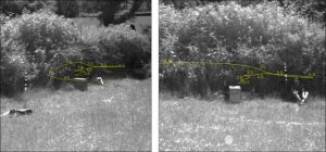
I’m working with a few research groups on this, but the main two groups are Natalie Hempel de Ibarra (Exeter) and Andrew Philippides (Sussex), who we’re applying for funding with.
- 3d flight path reconstruction
- finding the bee’s orientation using specially devised tags
- unique labels
The amount of hardware, coding, maths and fieldwork involved can be adjusted depending on what you would find the most interesting! To give a flavour of the maths: We use doubly stochastic variational inference to find the path of the bee. We use a raspberry pi and a custom 3d printed unit to house the tracking system, and a web interface to control it, in the field. [the initial development of the hardware basis for this is described in my earlier paper, but this paper doesn’t cover the stuff we’re working on now].
I’m also working with other groups who are using this tech for other insects (dragonflies etc).
Bee Tracking (using bluetooth)
I’m also about to put together a funding app with a collaborator in electrical engineering: The plan is to track bees (and other central-place foragers) using a bluetooth chip and tiny battery… again this will need a bit of maths etc, to get it working, happy to explain and discuss more :).
If you’re interested in applying for the funding to work on any of these projects, or want to discuss them further, please email me: m.t.smith@sheffield.ac.uk.
- practical: applying this to larger and more complex datasets [e.g. continent scale particulate pollution etc] – in the future this is particularly important when countries start to try to inventory their fossil CO2 emissions.
- mathematical: constraining the model (solving the problem of non-identifiability), non-linear modelling, etc.
- multiple outputs and multiple scales (from street scale to continental scale, etc).
- developing higher resolution maps of cities (e.g. by combining surface roughness maps with our advection diffusion model).
